Showing posts with label GCSE. Show all posts
Showing posts with label GCSE. Show all posts
Thursday, June 8, 2017
Sunday, March 12, 2017
AQA Geography Command Words
You can find a list of the AQA command words explained here:
http://www.aqa.org.uk/resources/geography/as-and-a-level/geography/teach/command-words
http://www.aqa.org.uk/resources/geography/as-and-a-level/geography/teach/command-words
Monday, March 6, 2017
Y11 Timed Conditions information
Please click here. This link is now public so there should be no problem downloading it.
Wednesday, February 3, 2016

Wednesday, January 27, 2016
Rising Sea Levels in the Maldives
Find a news report on Youtube showing MP’s from the Maldives signing a document underwater.
Watch it. Briefly explain what they were signing and why they are signing it
With aid of a map describe the location of the Maldives
Complete a factfile - population, GDP per Capita, main industries etc
Print out your work.
Tuesday, February 3, 2015

Monday, February 2, 2015
Doing Analysis in Coursework
Doing Analysis in Coursework
The idea behind analysis is to take data which you have collected and try to interpret what it tells you. The best way to do this is to take a graph(s) so that the data is presented, describe what the graph shows and then attempt to give reasons as to why the graph shows what it does. In this latter part you might refer to theory or process, for example, longshore drift.
Example
The Impact of Longshore Drift on Beach Profiles
Figure 8 Beach Transect 1
Figure 8 shows the beach profile of three transects which are shown on the map in the introduction. {puts the transects in context} The profiles are relatively shallow, however, gradient changes at -4 and at 5 metres on Transect 1 inland reflecting the change in slope. Transect 3 shows a build-up of sediment against the groyne giving the profile a slightly convex shape. {description} 
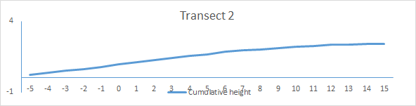

Given the location of the transects along the beach on the up-drift side of the groyne, these profiles are consistent with what would be expected as longshore drift is operating in a north-east to south-west direction on this stretch of beach. At transect 3 the convex shape is a result of sediment becoming trapped by the groyne and this is clearly shown in the photograph below.

Sunday, October 19, 2014
Resources for Coastal Fieldwork 2014-15
 |
| Picture from the Gulf News |
 |
| Dubai Coast from the air |
These are some resources that you might like to refer to in preparation for your fieldwork and coursework.
Another site
Dubai Municipality article
Also worth a read
Integrated Coastal Zone Management
http://www.dubaicoast.ae/ for local up to date information including live web cams at various points along the beach
Useful PDF article what can be accessed here. I’ve printed off a copy.
Google Earth allows the coast to be explored historically back to about 2003
Also, search google images for Dubai beach erosion
Gulf News article with fome excellent maps and photographs http://gulfnews.com/news/gulf/uae/environment/saving-dubai-s-beaches-1.217282
From the National newspaper
This site for a pretty hefty synopsis of the current situation
Coastal Care with some good video
Need for sand for Dubai’s beaches
Another useful site
Subscribe to:
Posts (Atom)